Maintenance of Savannah Harbor

The Savannah District maintains the navigation channel for safe and efficient passage of harbor ship traffic. Savannah Harbor consists of a bar channel 11.5 miles long, 44 feet deep and 600 feet wide, an inner harbor channel 21 miles long, 42 feet deep and 500 feet wide with a sediment basin that allows removal of harbor sediment at a reduced cost. Savannah Harbor handles the largest number of containers of any port on the South Atlantic coast and is 4th in the nation in import and export of container cargo. The harbor is also the rapid deployment Port of Embarkation for the 3rd Infantry Division and other elements of the 18th Airborne Corps. The harbor is maintained by two annual dredging contracts titled Inner Harbor and Entrance Channel.

View fact paper on Savannah Harbor Maintenance

The Inner Harbor dredging contract uses a Cutterhead Dredge to remove up to 7 million cubic yards of sediment from the channel and continues throughout the year while the Entrance Channel Hopper Dredge removes up to 800,000 cubic yards of sediment and is limited to December through March due to environmental considerations.
       
                           Cutterhead Dredge                                              Hopper Dredge

Savannah Harbor Dredge Disposal Areas

Up to seven million cubic yards (mcy) of sediments (sand, silt and clay) are removed each year from the Inner Harbor portion of Savannah Harbor Navigation Project by Savannah District maintenance dredging and placed at eight principal diked disposal areas on the north side of the channel.

The containment areas lie along the North side of Savannah Harbor from the mouth of the harbor to Georgia State Highway 25 (Houlihan) highway bridge. Containment areas upstream of US 17 highway bridge are in Georgia and downstream of the bridge are in South Carolina. The federal government, through Savannah District, is responsible for dredging accumulated sediment from Savannah Harbor navigation channel to maintain Congressionally authorized depths under the authority of the Rivers and Harbors Act of 1965, Public Law 89-298, passed by Congress on 27 October 1965. The project provides for incrementally raising each of the dikes within the federal project’s DMCAs at a cycle of one disposal area per year to increase their capacity as required to support the Savannah Harbor 42’ Federal Navigation project authorized in WRDA 1992. The increase in DMCA capacity is cost-shared with the State of Georgia under the authority provided in the Water Resources Development Act of 1996. The DMCAs are included as a part of the Savannah Harbor Federal Navigation Project authorized in the Water Resources Development Act of 1992. Section 201 of the Water Resources Development Act of 1996 addressed cost sharing for dredged material containment facilities.

All work in containment areas is completed using guidance and environmental clearances provided in the 1996 Long Term Maintenance Strategy. Rotational use of dredged material containment areas, environmental constraints, and environmental monitoring plan for the areas was established by the LTMS. Environmental monitoring is accomplished by a combination of Planning and Operations Division personnel.

Bank Protection Project

Collapse All Expand All
 Disposal Area 14A

The dikes in Disposal Area 14A in Savannah Harbor have been raised approximately 6 feet. Approximately 600,000 cubic yards of material was required for construction of the dike embankments. Also included in this project was clearing, silt fencing, grassing, raising two existing bird islands, relocation of 3 weirs and catwalks, extension of 3 outfall pipes, and placement of Geotextile material. This work was funded by the American Recovery and Reinvestment Act of 2009.
 Disposal Area 14B
Shore protection has been constructed along the existing bank of the Savannah River adjacent to Disposal Area 14B and tied into existing shoreline protection. The project includes approximately 8,660 feet on Disposal Area 14B. The material used for erosion protection is graded granite aggregate and armor stone placed at an elevation below +13 mean lower low water (MLLW). Minor excavation and fill is included in this work incidental to the rock placement. This work was funded by the American Recovery and Reinvestment Act of 2009.
 Disposal Areas 13A, 13B, and 14A

Shore protection is being constructed along the existing bank of the Savannah River adjacent to Disposal Areas 13A, 13B and 14A and tied into existing shoreline protection. The project includes approximately 6,670 feet on Disposal Area 13A, 3,320 feet on Disposal Area 13B, and 1,348 feet on Disposal Area 14A. The material to be used for erosion protection is graded granite aggregate and armor stone placed at an elevation below +13 mean lower low water (MLLW). Minor excavation and fill is included in this work incidental to the rock placement. This work is funded by the American Recovery and Reinvestment Act of 2009.

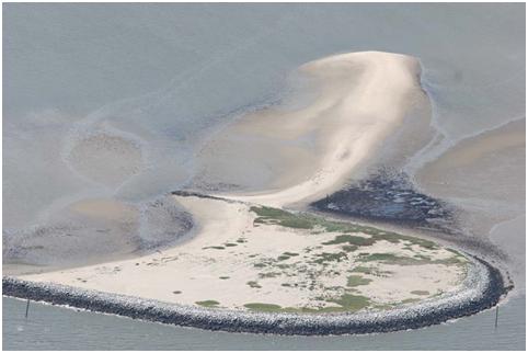
Tomkins Island Bird Habitat


As a result of dredging the channel, the Savannah District Corps of Engineers constructed a shore bird nesting island in the Atlantic Ocean offshore of South Carolina between Tybee Island, Georgia, and Daufuskie Island, South Carolina, named Tomkins Island. The island was specifically created for bird habitat and lies in the open ocean. The island provides rare protected habitat for a variety of beach nesting birds and created storage capacity in Jones/Oysterbed Island dredged material containment area, thus extending the life of that sediment containment area.

Click here for to view more photos

The island is named for Mr. Ivan Tomkins who was an employee of the Savannah District Corps of Engineers in the second quarter of the twentieth century. He was one of the first individuals to recognize the region to be rich in important bird habitat. Tomkins collected specimens and authored numerous articles on birds for Georgia and South Carolina environmental organizations and was a charter member of the Georgia Ornithological Society. His work led to Savannah Harbor dredged material containment areas now being recognized as “Important Bird Habitat” by Audubon of South Carolina.

Construction of the island was part of the mitigation requirements for continued maintenance dredging of Savannah Harbor, as part of the 1996 Long Term Management Strategy (LTMS) for Savannah Harbor.

Special features of the LTMS included an innovative wetland mitigation plan, a focus on bird habitat, cooperation with the US Fish and Wildlife Service. The LTMS required construction of the offshore island and the creation of fourteen one-acre islands within harbor dredged material containment areas as mitigation for creating a new dredged material containment area.